South East Queensland’s wetland action in the spotlight
Healthy Land & Water and a host of its partners across South East Queensland are delivering a range of activities to reduce threats and restore habitat in and around Quandamooka (Moreton Bay), alongside project delivery partners including Traditional Owners, private landowners, land managers, and local environmental groups.
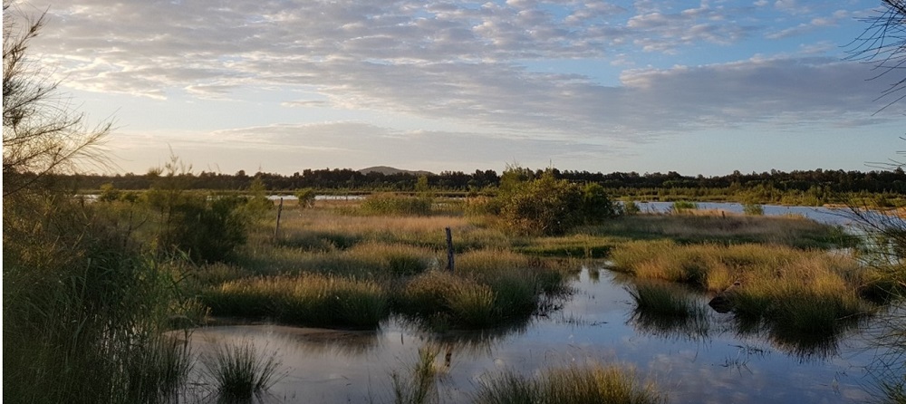
Our beautiful Moreton Bay.
Protecting our Moreton Bay with conservation projects
A range of projects is being delivered under the Moreton Bay Ramsar Wetland project, including coastal habitat restoration, shellfish reef creation, traditional fire management, erosion management, marine debris removal, and feral animal control.
These projects are reducing threats and restoring habitat in and around the Moreton Bay Ramsar site, resulting in increased numbers of threatened species, improved ecological function, and increased water quality.
Moreton Bay Ramsar Wetland
Quandamooka is recognised as an internationally significant wetland under the Convention on Wetlands of International Importance (the Ramsar Convention).
The bay and islands are made up of a diverse range of natural ecosystems, including the interface with the open ocean, sandy beaches, rocky shores, coral reefs, seagrass and sponge beds, mangrove forests, mudflats, and sandbanks, as well as freshwater wetlands.
Covering more than 120,000 hectares, it supports more than 50,000 wetland birds, including 28 species of migratory birds that travel from around the world to feed and roost, provides habitat for more than 750 species of fish, and the marine environment supports a high diversity of marine mammals including eight species of dolphin, five species of whale, and the dugong. All six marine turtle species known to exist in Australia are also found in Quandamooka (Moreton Bay).
Pressures are increasing, however, restoration efforts are showing promise
The latest mapping has revealed a decline in the extent of freshwater wetlands across most of South East Queensland over the last 20 years. Since 2013 alone there has been a further reduction of 280 hectares of freshwater wetlands recorded across the region, with only 45% of pre-clearing (before European settlement) wetlands remaining.
Wetlands are among the most productive ecosystems in the world and support high a diversity of plants and animals, improve water quality, and provide protection against flooding and erosion.
Losses are mainly due to the draining and filling or clearing of wetlands for intensive agriculture, infrastructure, and urbanisation on floodplains and lowland parts of the catchments. Development and urban run-off, littering, changes in the climate, and invasive species continue to threaten the health of our wetlands which in turn impacts the quality of our water, poses risks to multiple endangered species, and threatens our valuable biodiversity and ecosystems.
Despite a decline in wetland habitat extent across most catchments, in the lower estuaries of South East Queensland and Quandamooka (Moreton Bay), mangroves are increasing in spatial extent.
However, the benefits of increasing mangrove habitat may be counterbalanced by encroachment on saltmarshes and unvegetated flats, which can lead to reductions in some high tide roosting sites and feeding grounds used by migratory shorebirds, critical to their survival.
What Healthy Land & Water’s partners are doing to help wetlands in South East Queensland
Case study: Ipswich City Council’s Moodai Reserve Floodplain Re-engagement
The Moodai Reserve Floodplain Re-engagement project was a novel project aimed at improving water quality in an urban catchment by reconnecting a modified channel to its surrounding wetland ecosystem.
By re-engaging the floodplain and disconnected wetland, Ipswich City Council has restored a degraded paperbark wetland community and habitat to species such as green thighed frogs.
The project promotes groundwater recharge, recreates habitat for terrestrial and aquatic fauna and flora, and improves water quality. Importantly, it has represented the desires of the local community and provided opportunities to improve amenity and waterway stewardship.
The Moodai Reserve floodplain re-engagement project is funded through Ipswich City Council’s water quality offsets scheme. The project kicked off in 2020 and was completed in 2021.
Case study: Logan City Council’s Slacks Creek Catchment Recovery Works
Slacks Creek is a highly urbanised creek catchment in the heart of Logan City which, like many urban waterways, has suffered significantly from the change in catchment land uses and development.
Community concerns led Logan City Council to commission the Slacks Creek Catchment Futures Study in 2012. Borrowing from a Singapore waterway improvement model, Logan City Council implemented an Activate, Beautify, and Clean (A.B.C.) approach to achieving improvements in waterway health, ecological function in Slacks Creek and returning a degraded “drain” back into a functional waterway and valuable community space.
The Slacks Creek Catchment Recovery Project was originally a pilot initiative founded on strong community partnerships to improve waterway health and return valuable community space.
Over the last 10 years, a variety of projects have been achieved through the A.B.C philosophy of investment, leading to improved recreational value of the Slacks Creek Catchment and resulting in good ecological outcomes for the area. Over the last 18 months, the projects being deployed in the area have focused on providing an integral community connection along the northern section of Slacks Creek, a constructed wetland, bank stabilization works, weed removal activities, litter clean-ups and fish surveys, and habitat assessment.
In the last financial year, works continued with the installation of Slacks Creek Green Link, Garoona Park constructed wetland, Roselea Park bank stabilisation, Council’s Litter Clean-up, Coral Tree eradication program, and fish surveys.
Case study: Sunshine Coast Council’s Blue Heart project
The Blue Heart Sunshine Coast project is protecting floodplain function, enhancing water quality, and establishing new rural land uses, including economic opportunities for landowners.
A regionally significant complex of wetland and floodplain ecosystems is being restored, along with the rehabilitation of waterways and riparian areas. A 40-hectare area of former canelands is being converted to a blue carbon trial site and restored to tidal and freshwater wetlands over the coming years.
The Blue Heart provides flood storage for the Maroochy River Catchment. This is critical to the ongoing flood management of the catchment and in particular the built environment.
This floodplain area is already impacted by tidal inundation and over time is expected to continue transitioning due to climate change and projected sea level rise. The Blue Heart project seeks to manage the land and water through this transition to provide positive outcomes for our environment, community, and economy.
Blue Heart Sunshine Coast is an innovative partnership between Sunshine Coast Council, Unitywater, and the Queensland Government’s Department of Environment and Science. Other key project collaborators include Healthy Land & Water, local environment groups, rural landowners, and researchers. It is the first time a local council, a state government and a utility company have come together to protect and enhance a dedicated area for conservation, flood storage preservation, and recreation purposes.
Quick Moreton Bay facts
- Significant wetlands in our backyard
- Australia is home to 66 Ramsar wetlands, covering more than 8.3 million hectares across all our states and territories.
- Quandamooka (Moreton Bay) is one of Australia’s iconic wetland sites, covering more than 120,000 hectares.
- The Moreton Bay Ramsar site is home to many different coastal habitats and environments including freshwater wetlands, beaches, saltmarsh, mangroves, coral reefs, and seagrass beds.
- It supports more than 50,000 wetland birds and a high diversity of marine mammals and provides habitat for more than 750 species of fish.
- By working together and reflecting on our actions and choices, we can minimise our collective impact on the health of waterways.
There are lots of things people can do at home to help protect their local waterways, including:
- Buy eco-friendly products – Too many nutrients are bad for our waterways, look for ‘NP’ (No Phosphorus) laundry soap and ‘greywater safe’ products.
- Be conscious of your consumption – Everything has a water footprint. Explore ways to minimise your water consumption through the food you buy, for example, organic and plant-based foods.
- Limit food waste – This is better for your wallet and better for the environment.
- Invest in water-saving fixtures – For example, taps, toilets, dishwashers, and washing machines.
- Dispose of chemicals carefully – Don’t put oils, paints, or solvents down the drain.
- Avoid using weed killer before the predicted rain.
- Join a local catchment care group or environment group. Here is a handy list.
Why are wetlands important?
Wetlands are known as the kidneys of the catchment due to their ability to effectively improve the quality of water by filtering out contaminants. In addition to retaining water, they also play an important role in mitigating the impacts of flooding by retaining and then slowly releasing floodwaters.
Wetlands that retain water in the dry Australian landscape provide supporting habitat for many species, a role which will become more critical under projected increases in climate variability.
They produce clean water and food, improve water quality, and provide habitat for animals and plants. Providing many ecological and landscape benefits, wetlands are important for regulating gases providing shade and shelter for species, and providing cooler microclimates.
Wetlands and floodplains also provide a connected network throughout the landscape facilitating the movement of various species. The high diversity of plants and animals adapted to living in wetlands also provides biological control of pests in surrounding environments including farmland.
Unfortunately, recent mapping has revealed an overall decline in the extent of freshwater wetlands across most of South East Queensland since 2001.
This project is supported by Healthy Land & Water, through funding from the Australian Government’s National Landcare Program.
