
Erosion busters: how a SEQ program is punching above its weight
Did you know that a brilliant erosion-busting program is tackling this global issue head-on right here in South East Queensland?
For 13 years and counting, our Healthy Catchments program has been working at both ends of the spectrum, both delivering on-ground works and educating landholders to be able to identify and prevent erosion risks.
Now in its fourth phase, the hugely successful program started in 2010 and has been evolving ever since.
We are often asked what sets our program apart. We asked our roving reporter, Alberta, to investigate.
She has found that the answer not only lies in the program itself (she’s written up some of our latest work to give you the inside scoop), but also in the sheer amount of collaboration and adaptation along the way through working with the community. She says what is remarkable is the support and active participation of landholders and regional partners, without whom we would not have achieved the amazing results that we have!
Check out some of the latest projects for this long-running program, which is funded by the Queensland Government's Department of Environment and Science and runs in collaboration with landholders and communities in the targeted areas.
Landholders, regional partners, local contractors, and best practices: the keys to the Healthy Catchments program’s success!
Two great projects along the Warrill and Bremer Rivers
The end of June saw our team successfully complete two great projects along the Warrill and Bremer Rivers, with the support and active participation of landholders and our regional partners.
The Resilient Rivers Initiative, which Healthy Land & Water is a part of, and the Scenic Rim Regional Council were instrumental in the delivery of these projects – we shared our networks and skills and supported each other to ensure efficiencies, minimise duplication of effort and achieve the best results.
We have delivered multiple iterations of the program to repair and remediate gully erosion and revegetate riparian reaches along the Bremer, Warrill, and mid-Brisbane Rivers and Laidley Creek. All activities were made possible by the incredible support of landholders and landowners. They enabled access to the sites, maintained access tracks, installed fencing, watered the newly established vegetation on their land, and actively participated in the creation of multiple refuge gullies across their properties.
Bremer landholder project
Spanning property boundaries, we wouldn’t have been able to do the work, access the sites, or achieve any of the required outcomes without the help of landowners and the great trust and relationships we established.
This project used engineering and best management practices to stabilise three key locations along a gully. Works included:
- A leaky weir stabilises the active upstream headcut – a clay structure designed to slow water flow, filter the water through the vegetation, and reconnect the water to the surrounding floodplain.
- A bypass – a channel or drain to allow the excess water to enter safely into another gully system.
- An innovative cement mat chute to allow the water diverted by the leaky weir and the bypass to travel and reconcentrate into an existing stable gully.
- A small rock leaky dam slows the water down as the channel becomes narrower.
- Vetiver rows to revegetate the land along the gully and assist in erosion control and moving water across the landscape.
These landholders were also involved in our Bushfire Recovery Project to build the capacity and resilience of bushfire-affected communities.
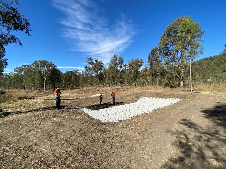 Cement mat chute being laid.
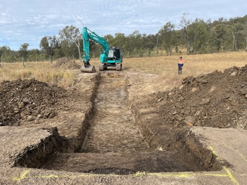 Earthworks to construct the leaky weir.
Warrill landholder project
This project used engineering and best management practices to stabilise a key location where the gully enters the Warrill River. Healthy Land & Water designed and installed the following structures:
- A cement mat and rock chute to slow down the water flow.
- Four pile fields to protect the gully bank.
- A one-metre-high rock wall along the outside bend of the gully.
- Battering and reprofiling around the gully to prevent further erosion and reduce the depth of the channel.
- Revegetation of the batter and planting of vetiver hedges to assist erosion control and moving water across the landscape.
This project was delivered in partnership and supported by funding from the Australian Government’s National Landcare Program.
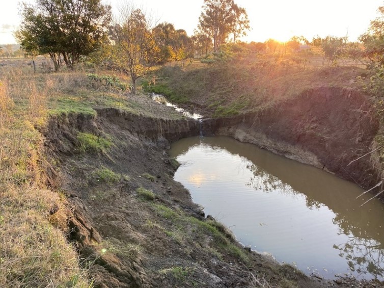
 The gully before works.
 The gully after works were complete.
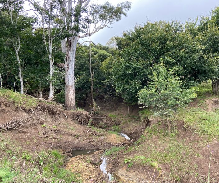
 Actively eroding gully head ~2 m deep.
 After, showing the cement mat and rock chute.
All the works carried out for both projects have employed local contractors and locally sourced materials.
These projects will be enhanced by similar works upstream and downstream carried out by the community and aimed at reducing sediment and increasing revegetation throughout the landscape to improve flood resilience and water quality.
More about the Healthy Catchments program
Reaches of the Upper Bremer, Upper Warrill, and Upper Laidley subcatchments were identified as the largest contributors of sediment into Moreton Bay in a 2010 joint Healthy Land & Water and Griffith University study.\
Knowing that streambank and gully erosion was (and continues to be) a major source of sediment entering our waterways, the program was developed to focus on gully and in-stream bank stabilisation to reduce erosion and improve water quality. Phase four of the program has been extended to include the Mid Brisbane subcatchment.
Keeping sediment in the landscape and slowing the water flow in the upper catchments prevents it from being mobilised into waterways and endangering the ecosystems downstream.
Reducing streambank and gully erosion protects productive agricultural land and, through targeted revegetation planting, can also increase bank stabilisation and rain infiltration, reduce surface runoff, and provide a stable area for sediment deposition, improving environmental outcomes for landholders as well as boosting flood resilience.
Through a combination of best practice technologies and project delivery, and sped along by impressive collaborations, the program has already successfully prevented between 10,000 and 12,000 tonnes of sediment from polluting waterways annually and stabilised 3.8 km of the targeted reaches of creek and gully banks, with earthworks, revegetation, and weed control.
This fourth phase focuses on works in the Bremer, Warril, and Mid Brisbane subcatchments, and will see a high number of small-scale gully erosion projects, paired with the establishment of a vegetated buffer area known as ‘refuge gullies’, and landholder education. Education is at the heart of the Healthy Catchments program, empowering landholders with essential knowledge to prevent major gully systems from forming and providing skills to design and construct small-scale gully remediation projects on their properties.
Beyond the environmental achievements, the program has also been instrumental in building community resilience, with hundreds of landholders benefiting from field day events focused on erosion risks and prevention activities. Read more here.
This program in all its phases has been funded by the Queensland Government's Department of Environment and Science and run in collaboration with landholders in targeted areas.
The agricultural outcomes have been delivered through funding from the Australian Government’s National Landcare Program.
The power of many, collaboration and best practice solutions have been paramount since day one of our Healthy Catchments program.
